US GeoReference Data
Smarty's US GeoReference Data gives you the US Census Tract and block data you need to easily comply with governmental regulations and gain access to the critical demographic insights you need to make your organization run smoothly.

Accurately relate demographic data to specific addresses with a persistent unique identifier (PUID).
Use the demographic data in stable block geographies for statistical analysis and business decisions.
Identify the Census Place names, IDs, and incorporated or unincorporated status of a city or town.
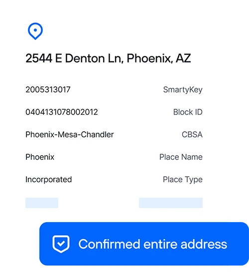
US GeoReference Data gives you the precise Census Tract data you need, including
The up to 15-character Census Tract and block ID.
The county subdivision identifier and name.
The GeoID for the CBSA and name.
The precise geographic city or town an address falls within and its incorporated or unincorporated status.
How you win with Smarty US GeoReference Data
Enhance US Census Tract identification
Improve government compliance
Match more Census Tracts
Identify locational demographics
Streamline data aggregation
Expand with confidence
Banks and financial institutions

Healthcare providers

Real estate technology

Super-fast Census Tract API
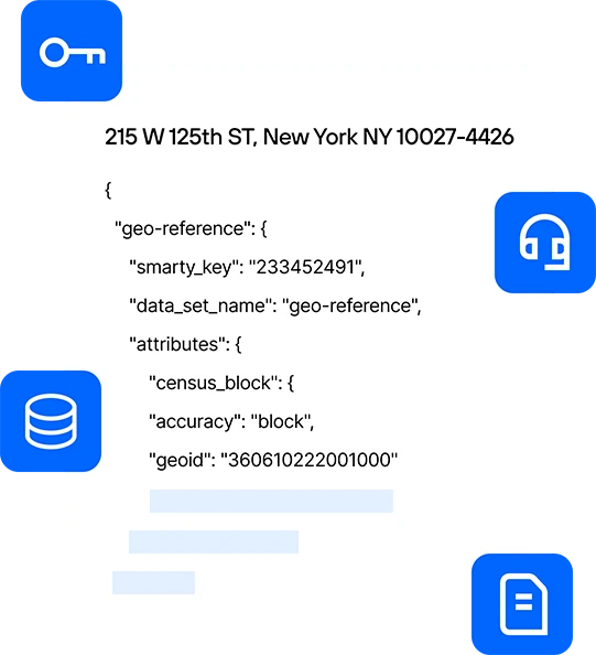
Get the correct census tract the first time. Smarty's US GeoReference Data stands on top of our already hyper-accurate US Rooftop Geocoding. When you enter an address, we immediately verify its accuracy and relate it to the correct census tract. Additionally, each of the returned census data points is accompanied by an accuracy rating, giving you a transparent view of the data you get back.
Getting the census tract data is one thing, but being able to relate that information to addresses and other crucial tools you're using is something else entirely. SmartyKey is a persistent unique identifier (PUID) assigned to every address in the United States. With the SmartyKey, you can easily and accurately tie the census tract data back to a location despite address changes.
When you reach out to our support team, they answer promptly. It's that simple. Smarty's support team comprises knowledgeable experts — no novices, no tiers, and no time-wasting scripts. Try us, and you'll agree that our unlimited, free support is better than other companies' paid support.
Packed with examples and sample code, our intuitive documentation helps you get up and running before you can shamelessly shout, "I love Smarty’s SDKs!" Read up on best practices and discover some of our pre-built open-source tools.
How others are using Smarty
What our customers are saying
Smarty support service is beyond excellent with time and accuracy. We had a technical issue and I sent an email. In just a few mins (less than 2 or so), I got a call and the issue was resolved in less than 5 mins.
FAQ
Smarty's GeoReference product has two easy ways to look up census tract and block information. First, suppose you need a simple, lightning-fast API to process many census tract lookups daily. In that case, Smarty's Address Enrichment API is easy to use and can process millions of addresses at industry-leading speeds. Second, you can use our census tract lookup tool to find the census tract ID, CBSA, place, and block ID individually.
A census tract is a small, relatively uniform, and stable area used for demographic analysis, typically containing 1,200 to 8,000 people. Each census tract provides detailed data on population characteristics, crucial for businesses and organizations in making informed decisions and tailoring strategies to specific communities.
The easiest way to find a census tract for an address is through a census API like Smarty’s. Smarty's GeoReference API provides a simple way for banks, lenders, real estate agents, and healthcare providers to access census tract and block information.
A Metropolitan Statistical Area (MSA), also called a Core Baesed Statistical Area (CBSA), is a geographic region with a high population density at its core and close economic ties throughout the area. It typically encompasses one or more urban cities and their surrounding communities, used for statistical purposes to analyze urban and suburban dynamics.